Livestock refuge mounds in North-West Queensland: Recent property visits and insights
Written by Harriet Dunne, Beef Extension Officer, Cloncurry and Bob Shepherd, Principal Extension Officer of Grazing Land Management, Charters Towers.
In early July 2025, representatives from CSIRO and the Queensland Department of Primary Industries (DPI) conducted a collaborative field inspection of properties in North-West Queensland to assess the design, condition, and performance of livestock refuge mounds. The team visited Donors Hill Station (Stanbroke) and Canobie Station (AACo), both located in flood-prone regions, to evaluate the effectiveness of existing mounds in providing refuge for livestock during major flood events. These inspections form part of a broader initiative to improve flood resilience and inform future mound design, construction and policy development.
Participants
- CSIRO: Justin Hughes (Principal Research Scientist, Hydrology) and Ian Watson (Group Leader, Agriculture and Food).
- DPI: Bob Shepherd (Principal Extension Officer – Grazing Land Management), Jane Evans (Beef Extension Officer), Harriet Dunne (Beef Extension Officer).


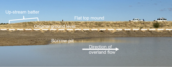
Donors Hill (Stanbroke) – Rectangular Mounds with the upstream-end a bull-nose shape
Three refuge mounds constructed in 2020 were inspected at Donors Hill. These were built after the 2019 event and have not yet been tested by flooding of that extent.
Key features:
- Dimensions: Length 200m with batters at approximately 1V:14H slope; width 65m with side batters at 1:6
- Top Area: 7,000 m²
- Average Height: 1.6m
- Carrying Capacity: will hold 780 adult equivalent (AE) cattle (where 1 AE = 450kg live weight), based on 9m² of area per head
- Construction Efficiency: Approximately 20m³ of soil per AE
The mounds had topsoil replaced only on the batters during construction, aiding in the establishment of dense pasture of predominantly hoop Mitchell grass two years post construction. The top of the mound was crowned, however after settlement the mound had a flat top. Supplementary feeding on the mound has been used to:
- Familiarise livestock with the mound location, hopefully improving their usage during flood events.
- Create a bio-blanket of cattle dung & urine to establish a dense pasture cover on the top of the mound.
When speaking to Brent Stevenson who was involved in the planning and construction, he said:
“Flood mounds allow safe and sustainable use of grazing land, giving managers confidence that even in unpredictable seasons animal welfare remains a top priority and those flood-prone paddocks can still be utilised”.
Each of these mounds are designed to hold 75% of the herd from that paddock and with multiple flood refuge mounds placed strategically in each flood prone paddock, greatly reduces risk of losses during flood events.
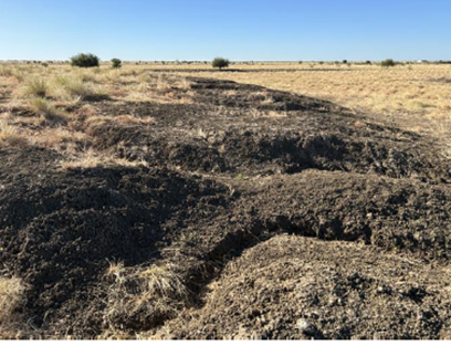
Soil erosion observations:
- Minor erosion on borrow-pit sides, likely due to runoff from the mound before pasture establishment.
- Minor erosion down the mound batters occurred before the pasture was fully established.
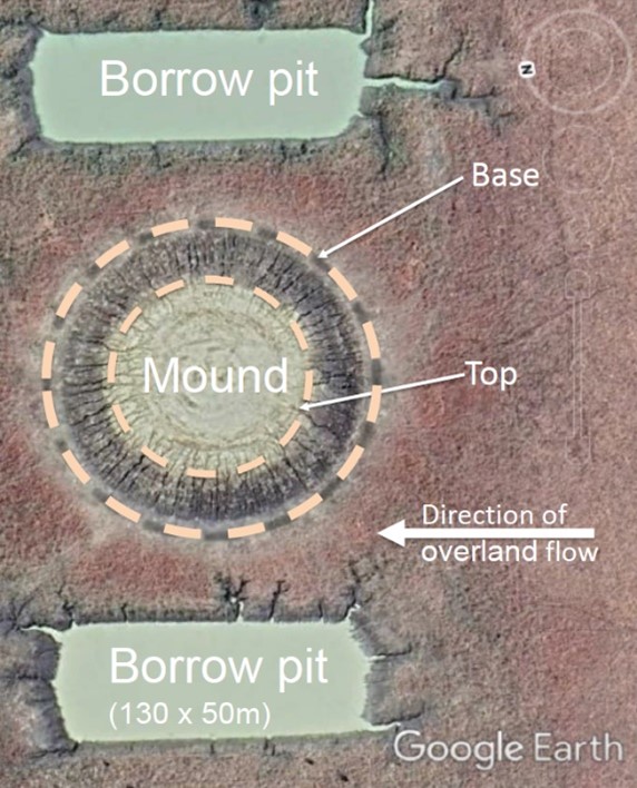
Canobie (AACo) – Circular mounds
At Canobie station, circular mounds were constructed after the 2019 flood. The site inspected on Canobie experienced a minor flood post-construction.
Key features:
- Dimensions: Base diameter 120m, top diameter 75m with batters averaging 1:12 slope (although some sections of the batter towards the bottom are as steep as 1:4. These steep sections are severely eroded).
- Top Area: 4,000 m²
- Average Height: 1.8m
- Carrying Capacity: Supports 490 AE at 9m² per AE
- Construction Efficiency: Approximately 29m³ of soil per AE.
The mound showed a variable pasture cover, ranging from sparse annual grasses to moderate perennial grasses after five years. No topsoil had been replaced during construction, which could be a factor in the lower pasture cover compared to the Donors Hill sites. The crowned-top, while essential for positive drainage and preventing low spots, was found to be too steep (2.0%) with a flat spot in the centre, possibly due to inadequate compaction, which raised concerns about potential boggy areas on the mound.
Key learnings and recommendations
- Topsoil replacement is critical for pasture establishment and mound stability. Topsoil replacement is also desirable at least on the batters of the borrow-pits.
- Constant gradient batter slopes of around 1V:6H or flatter are preferred to reduce erosion risks.
- Crowned tops are essential for drainage but should not exceed a 1.0% slope (ie 1V:100H).
- Subsoil compaction using a sheepsfoot roller in addition to compaction from the scrapers during construction, before topsoil replacement is vital for mound stability.
- Encourage livestock to become familiar with refuge mounds through supplementary feeding may improve their usage during flood events.
- Construction efficiency – for mounds with the same height, batter slopes and the same total carrying capacity, circular mounds require 23% less soil volume per animal than rectangular mounds.
Future Research Directions
- Examine the effect of distance between borrow-pits and mounds on erosion risk.
- Investigate how borrow-pit depth influences floodwater flow and speed.
Acknowledgements
We thank the station teams and managers for their cooperation and support during these inspections:
- Justin Anderson – Station Manager, Stanbroke, Donors Hill
- Brent Stevenson – General Manager – Primary Production, Stanbroke, Kamilaroi
- Jack Morris – Stanbroke
- Phil Acton – Station Manager, AACo, Canobie
- Clint Wockner – Northern Queensland Regional Manager, AACo, Carrum
These field visits provided valuable insights into livestock refuge mound design, construction and maintenance, and will help to improve livestock welfare in northern Australia through flood preparedness.
Producers affected by the 2023 and 2024 flood events are encouraged to share their experiences by completing our survey https://arcg.is/1ubWja2
The survey results will guide future livestock refuge mound improvements and flood resilience strategies.
Further reading
- Design, construction and management of Flood Refuge Mounds (2023) by Bob Shepherd, 👉 Download PDF, 4.5 MB