Have you seen MyFORAGE?
The Long Paddock website has provided climate and pasture products and information since 1995.
One of the leading products on the Long Paddock website is the suite of FORAGE reports. FORAGE is an online system that generates and distributes customised PDF reports with information for Queensland rural Lots on Plan greater than 1 hectare.
Now, users can access the ‘MyFORAGE’ online mapping tool. Developed by the Grazing Land Systems group from the Department of Environment and Science, the online mapping tool provides an interactive interface to input additional information for a property or area of interest, to enhance FORAGE report content.
Principal Scientist, Grant Stone, says “The Grazing Land Systems team are excited to be able to offer MyFORAGE as a new product in the FORAGE suite of tools and reports. It’s something we’ve been working towards for a while, and are keen to observe the uptake by Extension providers, consultants and landholders.”
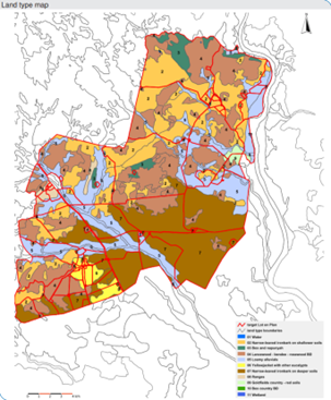
Property maps don’t need to be made from scratch either. MyFORAGE allows users to import an existing paddock file or property map also.
“By refining FORAGE reports down to a paddock level, decisions can be made at a paddock level,” Mr Stone continued. “Take phosphorus supplementation for example, using the new online mapping tool, users can anticipate phosphorus deficiencies of paddocks and match class of stock accordingly, or even prioritise supplementation. There is so much potential for a freely available product such as MyFORAGE.”
The MyFORAGE page has an introduction to the online mapping tool, as well as a short video, and a 4-page ‘Quick-guide’.
FORAGE reports incorporate a number of diverse data sources such as SILO climate data, satellite imagery and modelled pasture growth, to help decision-making in grazing land and environmental management. This automated system delivers over 4,000 reports per month to subscriber and ad hoc users – FORAGE has an amazing following!