 Why do we care about woody cover change?
Trees are a natural part of our landscapes but the woody cover they provide, can have both negative and positive effects on pasture growth, depending on the situation. They can compete with the pasture layer for soil nutrients and water and lead to reduced pasture growth, especially on the most fertile and productive land types. Conversely, trees on low nutrient soils can sometimes promote pasture growth because they add nutrients to the soil surface from their leaf fall and the shade and shelter they provide improves the microclimate by decreasing soil temperature and evaporation.
Woody vegetation thickening can change grasslands to closed woodlands and forests with little pasture growth underneath. This can lead to declines in birds that rely on grassland habitat across northern Australia. Once a forest establishes it can be difficult to reverse, even with fire, because the trees prevent grassy fuels from building up.
What drives woody cover change?
Soil type, rainfall and atmospheric carbon dioxide levels all affect the carrying capacity for woody plants (the maximum potential woody cover that a site can grow). Clay soils tend to have lower cover, and increases with rainfall. Increasing concentration of carbon dioxide in the atmosphere is implicated in woody vegetation increases worldwide. Conversely, drought can lead to extensive die-off of woody plants. Changed water flows across the landscape due to land condition decline can also influence woody cover.
Landscape use can influence whether woody cover reaches its potential for that environment. Anything that consumes woody plants, like fire or browsers (giraffes, elephants, the now extinct browsing giant kangaroos) can reduce woody cover. Conversely, grazing of the pasture layer can indirectly lead to increased woody cover by reducing the fuel to carry fires, and hence reducing the consumption of woody plants by fire. Heavy grazing of the grass layer also increases woody plant growth by reducing competition from the pasture for water and nutrients and by decreasing the shading of emerging woody plant seedlings.
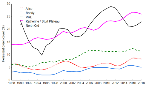
Woody cover change in the last 30 years across the Territory and North Queensland
Landsat satellite vegetation cover data is available from 1988. We have used it to assess ground cover and woody (trees and shrubs) cover trends through time over the last 30 years. Persistent green cover is the cover that stays green all year round and is used here as a proxy for woody cover.
We collated Landsat-derived cover data for more than 150 grazing trial paddocks across northern Australia. Although these paddocks are not necessarily representative of entire regions (the Victoria River District (VRD) and Barkly trial paddocks tend to be mostly black soil, while the Katherine paddocks tend to be more red soil), they do offer insights into where and how much woody cover is increasing (Figure 1).
In the Alice Springs region there was no real trend, fluctuating between 4 and 9% woody cover throughout the 30-year period. In all other Territory regions woody cover increased by 60 to 85% over three decades. This is not something you would notice year-to-year. The average increase in woody cover per year was only 0.1 to 0.4%. Our landscapes have been altering “slower than the eye can see”, as Daryl Lewis wrote in 2002 in his case study of woody thickening in the VRD. Woody increase appears to have plateaued in the VRD and Barkly after 2006, but not in the Katherine region, where it continued rising until 2016.
The Queensland sites had much greater variation in woody cover over time than occurred in the Territory regions, possibly reflecting the more frequent extended dry periods in eastern Australia. Woody cover changed in tandem with the trends in rainfall, crashing with extended droughts (Figure 2) and increasing in wetter periods, finishing at similar levels to 1988. Drought index was highly correlated with woody cover patterns through time, explaining 66% of the variation.
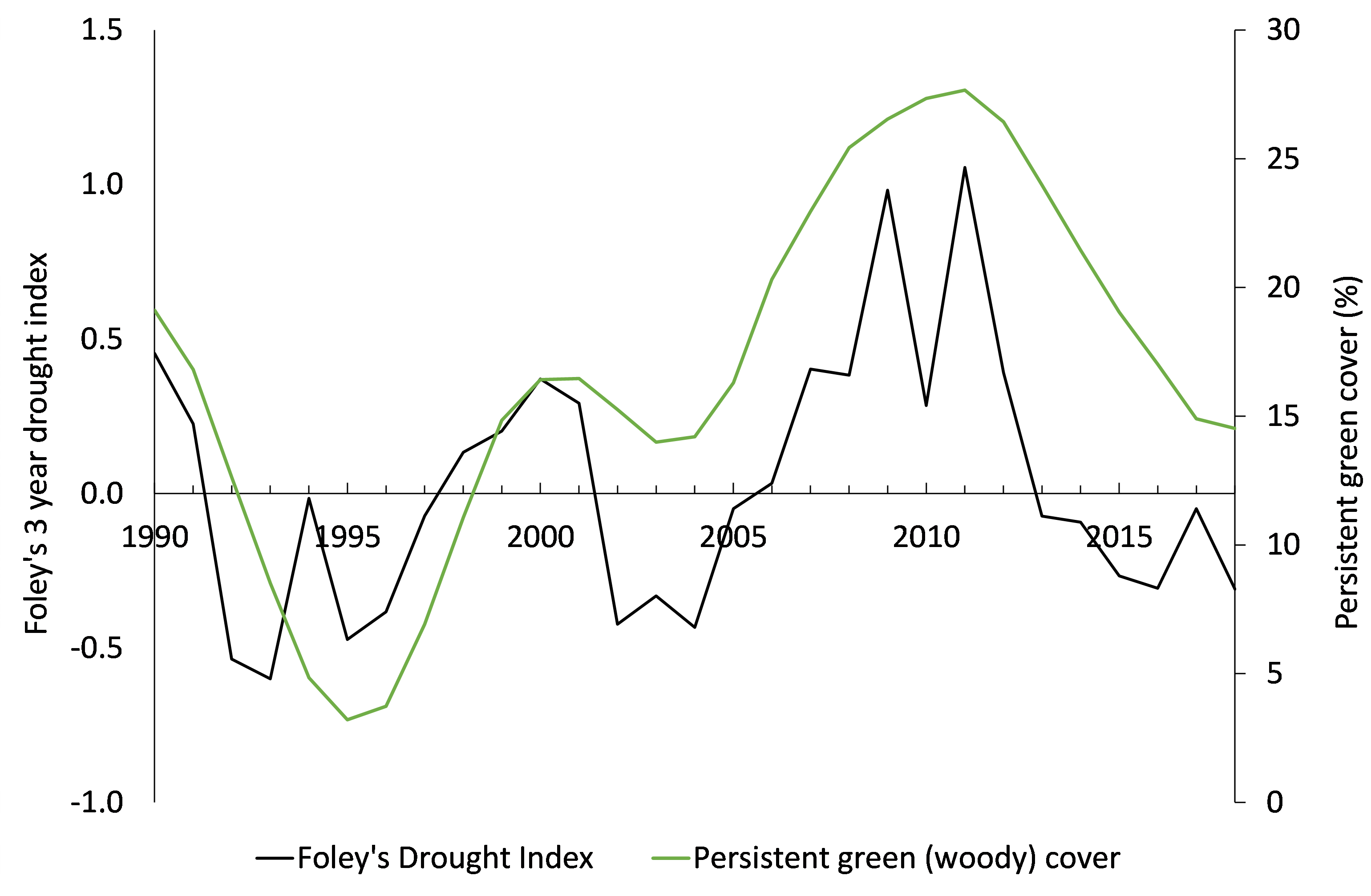
Note: Foley’s three-year drought index is based on Trafalgar Station financial year rain. Above and below 0 values indicate extended periods of wetter or drier than long-term median rainfall. The drought index is calculated as the sum of the previous three years’ percentage of deviation from the median rainfall. It provides a measure of extended above and below median rainfall periods.
There is ongoing debate about whether rainfall, or grazing and fire are the predominant factors affecting woody cover on grazed lands. Woody cover increases during above-average rainfall years are often reversed in drier periods with mass tree dieback. In the Queensland example, natural fluctuations in woody cover appear to have reversed with drought.
Further detail about factors affecting an increase of woody cover at Kidman Springs and what that can tell us about managing our grazed landscapes, can be read here.
Acknowledgements: Thanks to the Remote Sensing Team from Queensland Department of Environment and Science for providing Landsat cover data for grazing trial paddocks.
This article has been written by Robyn Cowley, Livestock Industries, Northern Territory Department of Industry, Tourism and Trade.
More information
- Results of the long term Kidman Springs fire experiment can be found, here.
- Use of fire in grazed woodlands