Demonstrating alluvial gully remediation techniques in the Upper Burdekin Catchment project
Page published: January 27, 2026 | Page reviewed: February 17, 2026
Background
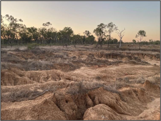
Gully erosion is a significant challenge in grazing lands across northern Queensland, particularly inareas with highly erodible soils. These gullies can drastically reduce the productivity of grazing land, reduce water quality for downstream environments, and require ongoing costly interventions if left unmanaged. This project focuses on addressing this issue by trialling practical, cost-effective remediation techniques on Spyglass Research Station.
The methods trialled improve long-term soil condition and reduce the need for ongoing maintenance, based on suggestions from technical experts, graziers, and earthmoving contractors. These include high-intensity works with major earthworks, engineered erosion-control structures, and extensive soil amendments across the treatment areas; and medium-intensity works using smaller scale earthworks targeting smaller gullies in line with typical grazing-enterprise capacity.
Preliminary key messages
Alluvial gully remediation on hostile soils and moderate catchment sizes is expensive but greatly improves landscape function and reduces sediment pollution.
Simpler solutions relevant to Upper Burdekin graziers with heavy earthmoving machinery have had early success following basic fundamentals in alluvial gullies with small catchments and moderately hostile soils.
Getting an experienced person to assess your gullies will help in choosing what you can tackle with your resources and in implementing the lessons learnt in other projects.
Alluvial gullies differ from hillslope gullies in their location, scale, and behaviour. Hillslope gullies typically form on sloped land as narrow, linear erosion features. They are smaller in size and tend to stabilise naturally once their water source (catchment) is exhausted. In contrast, alluvial gullies occur on flat floodplains near rivers and are much larger and more complex. They erode deeper and wider into the landscape, producing significantly more soil loss. Unlike hillslope gullies, alluvial gullies continue to grow over time, even with limited or no external catchment, making them far more challenging to manage and stabilise.
Project objectives
Objective 1: Monitoring and research
Improve understanding of cost-effective alluvial gully remediation techniques to inform industry, policy, and research.
Conduct detailed monitoring (e.g., LiDAR, water quality sensors, vegetation assessments) to track sediment load reductions and land recovery.
Objective 2: Knowledge and skill building
Provide opportunities for site visits to improve understanding of gully remediation among graziers and technical experts.
Increase knowledge through videos, reports and factsheets.
Objective 3: Erosion control and sediment reduction
Trial various remediation options to remediate erosion and reduce sediment flowing from Continong Creek to the Burdekin River.
Focus on improving soil stability and vegetation cover for long term stability post-remediation.
Site challenges
Alluvial gullies in northern Australia face significant challenges due to harsh climatic conditions and erosive and low fertility soils. Long dry periods stress vegetation, while short, intense wet seasons bring damaging storms and rapid river level changes. On the Burdekin River, steep slopes from the high alluvial terrace to the low riverbed accelerate erosion, particularly during early wet season storms when vegetation cover is sparse.
The alluvial terrace soils are highly erodible, with subsoils dominated by slaking and sodic clays (ESP up to 58.7%). These soils are dense (mean >1.6 g/cm³) and unstable (electrochemical stability index as low as 0.005), with fine sediments clogging soil pores and preventing root penetration. High pH (up to 8.7), naturally high salinity (up to an EC1:5 of 1.74 dS/m), and chlorine toxicity (up to 2780 mg/kg) further inhibit plant growth, making it difficult to establish stabilising vegetation. Soil conditions vary across the site, with some areas experiencing only slaking soils, while others exhibit the full suite of challenges.
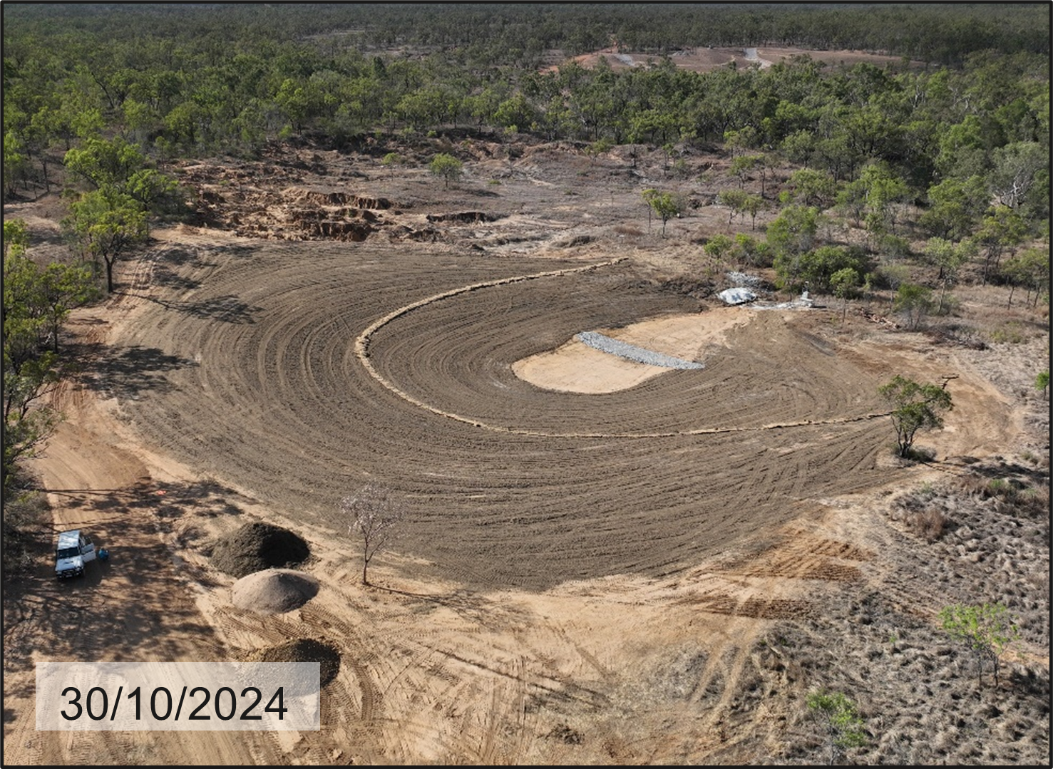
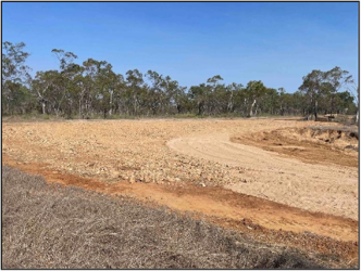
The high intensity treatment sites at Spyglass test a range of resource-intensive remediation techniques designed for severely degraded gully systems where maximum sediment reduction is a priority, like the suite of works carried out in the Bogie, Bowen and East Burdekin catchments. Ten treatments were implemented across two locations (Figure 1), involving extensive earthworks to reshape eroded landforms, the installation of rock chutes, channels, rock checks, and diversion banks to manage water flow, and the deep incorporation of organic matter and gypsum to improve subsoil structure.
These approaches are best suited to large-scale applications due to their cost and complexity. However, they aim to address key failure mechanisms commonly observed in alluvial gully remediation, namely, surface erosion from rain splash and rill erosion caused by concentrated flow.
The core remediation strategy includes:
Landform reshaping to manage drainage and reduce flow concentration.
Subsoil treatment with gypsum and organic matter to improve structure and stability.
Establishment of persistent vegetation to stabilise the surface and protect against further erosion.
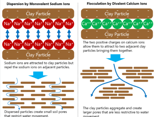
Gypsum – Calcium Sulphate (CaSO4)
Gypsum is commonly applied to ameliorate sodic (Na) soils. It works by helping clay particles hold together in aggregates, improving soil structure and water infiltration. Improved soil structure supports plant growth and stops the clay particles from dissolving in rainwater and washing away. Gypsum achieves this by introducing calcium to the negatively charged clay particles in the soil. The calcium (strong charge) displaces the sodium (weak charge) off the clay particles and takes its place. The stronger charge of the calcium pulls in other clay particles, causing soil aggregation (stronger soils) and improving water infiltration (less runoff), helping combat erosion and improving plant growing conditions. The displaced sodium then gradually leaches away (Figure 2).
The baseline sodium level to address was determined by analysing the largest contributing soil layer in areas of exposed cut and fill. Although some areas had an ESP of 58.3%, the target ESP used for remediation was a reduction from 9% to 6%. To achieve this, 2.5 tonnes of gypsum per 100 mm depth of soil was applied.
Figure 1. Clay particles repelling each other with high Sodium (Na) levels and aggregating with additional Calcium (Ca) (Utah University Extension, 2023).
Organic matter
This project is investigating the potential of organic matter to assist in soil remediation, particularly its ability to improve structure, stability, and support plant growth in highly degraded subsoils. The idea is that, when incorporated, organic matter will stimulate microbial activity, which in turn could help form soil aggregates; clusters of particles bound together by biological, physical and chemical processes. These aggregates enhance soil stability, improve infiltration, and reduce erosion risk.
In gully remediation in northern Australia, gypsum alone may be too slow to deliver short-term improvements. It relies on extended contact with water to dissolve and influence soil chemistry, a challenge in landscapes where intense seasonal rainfall often runs off rather than infiltrate. The project is trialling a combined approach, mixing organic matter with gypsum to see whether it can provide earlier structural improvements. The hope is for faster stability to allow infiltration, allowing gypsum to gradually dissolve and contribute to longer-term improvements in soil condition.
A key part of this work is exploring how soil aggregation develops under different treatments. Aggregates are thought to form around plant roots, fungal threads, and organic residues. Actively growing vegetation, particularly grasses, reinforce these aggregates through fine root systems and supporting biological activity. Over time, this living network helps build a more resilient and functional soil profile.
In these trials, organic matter was incorporated to a depth of up to 300 mm in subsoils that are typically very low in organic carbon. Many samples contained less than 0.2% organic carbon, which is below the threshold needed for stable aggregate formation.
To test this, mill mud, a by-product from sugar cane processing, was used as the main organic input due to its high carbon content and availability in bulk. Since freshly produced mill mud may have low microbial activity due to processing, composted cattle manure and woodchip was added to introduce beneficial microbes and support biological processes that contribute to aggregate formation and improved soil structure.
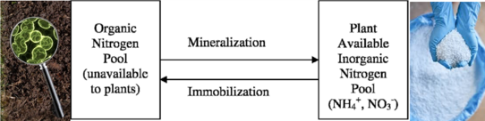
Carbon and nitrogen
The carbon-to-nitrogen (C:N) ratio is critical for determining nitrogen availability to plants. When the ratio is high (lots of carbon but little nitrogen), nitrogen can become “immobilised” within organic matter and microbes, making it temporarily unavailable for plant uptake.
Microbes drive the breakdown of organic matter, using carbon as their energy source and nitrogen to build their biomass. In high-carbon environments, microbes draw nitrogen from the soil to meet their needs, effectively locking it up in their bodies. This nitrogen becomes available again only after the microbes die and decompose, a process known as mineralisation (Figure 2).
Figure 2. Microbes determining the nitrogen movement between organic and inorganic pools.
Applying large amounts of nitrogen to compensate for this imbalance may seem logical, but nitrogen is highly volatile. If over-applied or poorly timed, it can be lost through volatilisation (as gas), runoff, or leaching below the root zone. These losses are costly, inefficient, and contribute to greenhouse gas emissions and nutrient pollution in waterways.
Plant growth is optimised when the C:N ratio is balanced, ideally between 10:1 and 12:1, to avoid both immobilisation and volatilisation. In this project, organic amendments such as compost, bagasse, and mill mud resulted in initial C:N ratios exceeding 21:1.
Two contrasting strategies were trialled to manage this imbalance:
Passive approach: No additional nitrogen was applied, assuming the organic amendments contained sufficient nitrogen. Microbial activity was expected to naturally rise and fall, gradually releasing nitrogen as the C:N ratio balanced over time.
Capital application: Nitrogen (as urea) was applied to adjust the C:N ratio from 21:1 to 12:1. This aimed to accelerate organic carbon breakdown, reduce the period of nitrogen immobilisation, and minimise the risk of nitrogen deficiency during plant establishment.
Base cost summary
Distribution of shared expenses before individual treatment implementation
Table 2. Distribution of shared expenses before individual treatment implementation
Activity
Jackey Jackey
%
Gilbert
%
Site area (m2)
24,830
8,090
Design
LiDAR scanning, 3D designs and project costs
$51,551
8.3
$22,094
17.2
Soil tests
$500
0.1
$500
0.4
Construction
Reprofiling and tree clearing
$219,185
35.3
$54,409
42.4
Create rock chutes and checks
$251,171
40.5
$12,606
9.8
Spread bagasse
$65,487
10.6
$26,175
20.4
Labour
Project management - 100 days
$32,500
5.2
$12,500
9.8
Costs (excluding treatment costs)
$620,394
100%
$128,284
100%
$/m2
$24.99
$15.86
High intensity treatment cost comparison
Activity
JJ1a
JJ1b
JJ1c
JJ1d
JJ1e
JJ1f
JJ2
JJ3a
JJ3b
G2
Site area (m2)
1,160
1,260
1,320
800
1,050
1,350
16,510
680
700
8,090
Design, construction and labour
28,984
31,483
32,982
19,989
26,236
33,729
412,512
16,990
17,490
128,284
Treatment:
Trenches + material imbedded
-
3,536
-
-
-
-
-
-
-
-
Gypsum
153
175
66
22
131
175
2,273
197
197
-
Mill mud & compost + application
1,950
2,040
1,932
-
1,588
1,552
58,429
2,275
1,471
34,004
Gravel layer
-
-
-
8,799
-
-
-
-
-
-
Scarifying
103
112
117
71
-
-
1,466
60
62
945
Spreading topsoil
1,987
-
-
5,299
-
-
-
-
-
-
Deep ripping
-
-
-
-
325
325
-
-
-
-
Nitrogen
-
-
-
-
-
310
-
620
-
-
Place hay lines
-
-
-
188
245
254
2,035
94
94
1,261
Seed + application
129
140
147
88
116
149
1,830
76
77
897
Maintenance
8,310
8,805
Total cost ($)
33,306
37,486
35,244
34,456
28,641
36,494
486,855
20,312
19,391
174,196
$/m2
28.71
29.75
26.70
43.07
27.28
27.03
29.49
29.87
27.70
21.53
The treatments
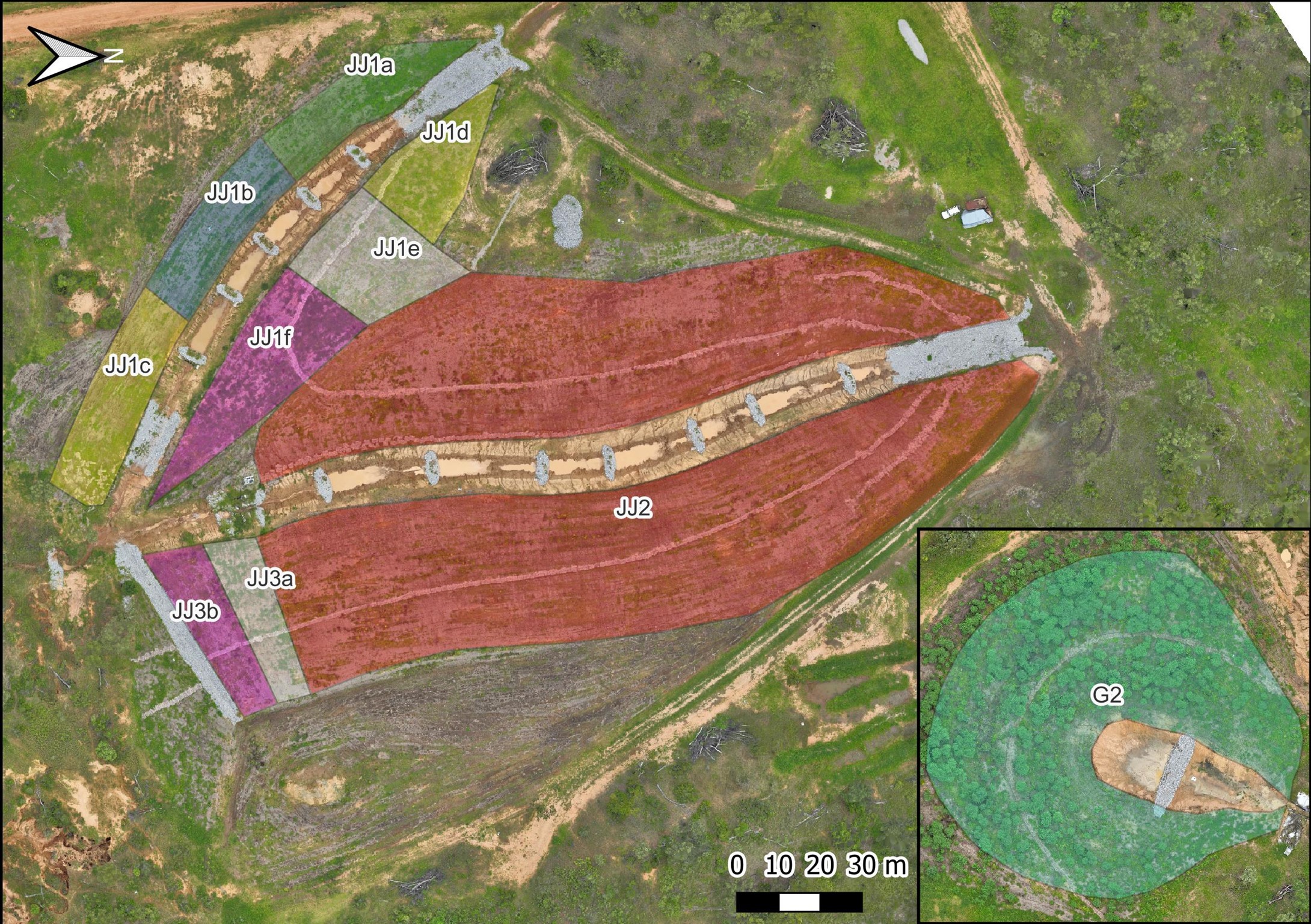
Map of High Intensity remediation sites at Spyglass, Jackey Jackey (JJ) and Gilbert (G) (right hand corner) sites.
High intensity treatment concepts. All treatments received: 1V:6H slopes, 40mm cane fibre (bagasse) mulch and sown shotgun seed mix (Rhodes, Couch, Bissett, Japanese Millett, Urochloa).
Organic matter target rate by depth
Gypsum rate
Incorporation and depth
Additional treatment variations
JJ1a
Half rate to 300mm
7.5t/ha
Scarified to 300mm
100mm topsoil
JJ1b
Half rate to 300mm
7.5t/ha
Scarified to 300mm
Three 500mm deep trenches with compost and sulphate of ammonia at bottom
JJ1c
Full rate to 100mm
2.5t/ha
Scarified to 100mm
JJ1d
2.5t/ha
Scarified to 100mm
100mm topsoil, 100mm gravel under topsoil
JJ1e
Half rate to 300mm
7.5t/ha
Deep ripped to 500mm
JJ1f
Half rate to 300mm
7.5t/ha
Deep ripped to 500mm
Half rate nitrogen
JJ2
Full rate to 300mm
7.5t/ha
Scarified to 300mm
JJ3a
Full rate to 300mm
7.5t/ha
Scarified to 300mm
Full rate nitrogen
JJ3b
Half rate to 300mm
7.5mm
Scarified to 300mm
G2
Full rate to 300mm
Scarified to 300mm
JJ1a – Half rate organic matter with topsoil
Concept
JJ1a tests the effectiveness of adding a 100mm layer of topsoil alongside deep incorporation of gypsum and organic matter (OM) as part of a high-intensity alluvial gully remediation strategy. The aim is to assess the added value of topsoil in combination with deep amelioration, particularly its role in improving soil structure, increasing water infiltration, and supporting rapid vegetative cover.
JJ1b – Deep banding with organic matter and gypsum to 300mm
Concept
JJ1b explores whether plants can be encouraged to drive their own subsoil remediation over time. While gypsum and organic matter were incorporated at 300 mm, this treatment added nutrient-rich “lures” (organic matter and sulphate of ammonia) in deep trenches below the amended layer. The aim is to attract roots into hostile subsoils, allowing living roots stimulating a microbial community to improve structure, infiltration, and organic carbon at depth, using fewer inputs.
JJ1c – Full rate organic matter and gypsum to 100mm
Concept
JJ1c tests whether shallow incorporation of organic matter and gypsum (to 100 mm depth) is sufficient to improve soil stability. The treatment aimed to reach the target organic carbon rate to promote aggregation and structure at the surface, while using gypsum to support longer-term stability, without the need for deep mixing and thus high volumes.
JJ1d replicates the most effective treatment identified at Strathalbyn, using a layered “cake” approach rather than organic matter-driven remediation. Gypsum was applied and scarified into the top 100 mm, followed by a 100 mm rock layer for stability, and topped with 100 mm of topsoil to support vegetation and protect the structure.
JJ1e – organic matter and gypsum to 500mm
Concept
JJ1e investigates the risk–reward trade-off of deep ripping to 500 mm to promote infiltration. The rough surface aimed to increase water entry and reduce slope runoff, potentially improving plant access to deeper soil moisture. However, this approach carries the risk of encouraging flow concentration and rill erosion.
JJ1f – organic matter and gypsum to 500mm with microbial pre-feeding
Concept
JJ1f builds on the JJ1e infiltration concept, combining deep ripping to improve water entry with a pre-emptive urea application to address potential nitrogen immobilisation. The aim was to support microbial activity and ensure nitrogen remained available for establishing plants despite high carbon inputs.
JJ2 – Full rate organic matter with gypsum
Concept
JJ2 serves as the primary demonstration site for testing deep incorporation of organic matter and gypsum to improve soil structure and stability. The treatment aims to elevate soil organic carbon to levels that induce aggregation, while also supplying nutrients to support plant growth. Gypsum was included in the mix to improve the soil cation balance over time. The theory is that organic matter will rapidly enhance structure, allowing gypsum to dissolve and act more effectively, ultimately creating a stable, well-aggregated surface that supports vigorous vegetation.
JJ3a – Full rate organic matter with gypsum and microbial pre-feeding
Concept
JJ3a follows the same core approach as JJ2, with a full rate of organic matter and gypsum incorporated to 300 mm to improve soil structure and cation balance. In addition, a capital application of nitrogen (as urea) was included to pre-empt microbial demand and reduce nitrogen immobilisation. The aim was to ensure sufficient nitrogen was available for both microbes breaking down the organic matter and for germinating plants, supporting rapid establishment and reducing the risk of early nitrogen deficiency.
JJ3b – Half rate organic matter with gypsum
Concept
JJ3b applies the same organic matter and gypsum approach as JJ2, but at half the organic matter rate. The aim is to assess whether a reduced carbon input, targeting only half the organic carbon level needed to induce aggregation, can still deliver meaningful improvements in soil structure and stability when mixed through to 300 mm depth.
Gilbert 2 – Full rate organic matter without gypsum
Concept
G2 tests the impact of organic matter alone by applying a full rate mixed to 300 mm depth, without gypsum. This treatment helps isolate the effect of organic matter on soil structure, aggregation, and plant response, allowing comparison with other sites (like JJ2) to infer the added valueof including gypsum in the mix.
The medium intensity treatment sites have been established to provide practical examples of gully remediation techniques for alluvial soils. These sites aim to reflect erosion challenges commonly encountered across grazing properties and demonstrate how they might be addressed using typical property-scale machinery and locally available materials, with minimal external inputs.
These sites are intended for graziers to visit, see whether the erosion problems resemble those on their own properties, and decide if the approach taken here seems effective and achievable with the tools and materials, they have available. The accompanying fact sheets detail the methods trialled, the materials used and comments on effectiveness.
Alluvial soils, particularly those affected by tunnel erosion, are notoriously difficult to stabilise. Some treatments trialled here are experimental in nature and are being compared to more involved approaches such as full excavation, soil treatment (e.g., gypsum incorporation), and re-compaction to assess their effectiveness and feasibility. Assessing the long-term stability of these treatments takes time, so we encourage visitors to view the sites with that in mind and consider revisiting in future years to see how the outcomes evolve.
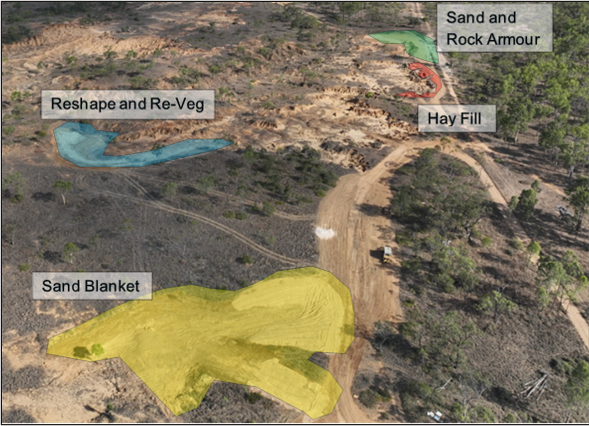
Figure 4. Medium intensity gully remediation sites after treatment, 2024
The four medium intensity treatments trialled at Spyglass are:
Sand blanket: Trialling the use of sand to fill and suppress tunnel erosion.
Reshape and revegetate: Using reshaping and revegetation in relatively stable soils with minimal inputs.
Sand and rock armour: Combining sand infill with locally sourced rock to control surface water and stabilise tunnels.
Hay fill: Filling erosion features with surplus hay to assess its potential to trap sediment and slow gully progression.
Sand blanket
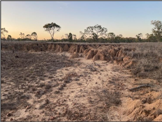
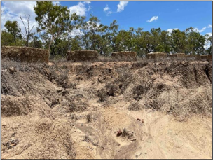
Figure 5. Tunnel erosion still present after reshaping, 2024
Figure 6. Sand blanket over areas of tunnel erosion, 2024
Background
The sand blanket site was selected due to aggressive tunnel erosion at the gully head, despite high ground cover.
Concept
The gully was diverting away from the rock bar, leading to the risk of secondary incision. To address this, a diversion bank was constructed to redirect flow back onto the exposed rock, using it as a stable spillway.
The sand blanket technique is based on previous trials where sand was used to fill individual tunnels following surface collapse. The theory is that as the tunnel continues to erode, sand packed into the opening will gradually fill the void. Water can still move through the sand, but fine soil particles are less likely to be transported, helping to stabilise the area.
At this site, we extended the concept by proactively applying sand across the area to reduce the need for ongoing maintenance. Instead of targeting individual collapse points, the site is roughly reshaped using a dozer or loader, leaving existing tunnels intact. A deep blanket of sand is then spread over the surface, with the expectation that it will gradually settle into the tunnel voids. If subsidence occurs, additional sand is applied until the surface remains stable.
This approach avoids the alternative method of fully excavating the tunnels and rebuilding the profile, which involves double handling soil and requiring more specialised machinery.
So far…
Initial runoff impacts were underestimated, with even small catchment areas causing significant sand movement.
Recommendation: Manage drainage across the batter using either a rock-lined drain or apply an organic cover or bund to help hold the sand in place until vegetation establishes. In this case, a rock drain was installed, and vegetation has since successfully stabilised the sand.
The diversion bank has worked well and appears stable.
Sand blanket activity costs
Activity
Resources
Cost
Per m2
Reshape gully head and construct diversion wall
Bulldozer (D7 equivalent) x 10 hours
$5,815
$1.66
Spread gypsum over reshaped subsoils
Spreading: 0.5 hour labour
Gypsum @4t/ha (150kg)
$100
$0.33
Sand quarrying and spreading over tunnelled area
Digger and moxy: 10 hours
150m3 sand @ 300mm depth
$5,815
$1.66
Apply seed (as in high intensity)
Hand broadcast: ½ hour
Seed mix: 15kg
$65
$320
$0.02
$0.09
Construct small rock drain/chute
5.5t excavator and tip truck: 5 hours
$1,155
$0.33
Place hay in small rills to hold the sand together
Hay: 0.1 bale and ½ hour spreading
$50
$0.01
Total
$13,000
$3.71
Reshape and re-veg
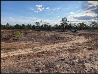
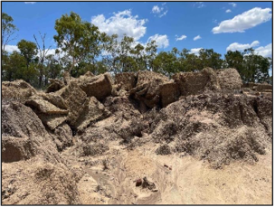
Gully scarp retreat, 2024
Reshaped gully showing scarification and hay bunds, 2024
Background
This site was selected due to the rock expression in the floor and natural rock chute nearby, limiting further gully floor erosion and secondary incisions. The main erosion issue at this site was the backward retreat of the gully head caused by highly slaking, non-dispersive soils, rather than tunnelling.
Concept
The technique trialled at this site focused on identifying a highly erodible soil type that lacked major constraints to vegetation establishment, such as salinity, alkalinity, or high bulk density, and testing low-input revegetation methods. Once the site was selected, the gully edge was mechanically reshaped into a stable 1V:8H batter, scarified to improve infiltration, seeded, and lined with hay bunds along the contour to reduce rill erosion during early storm events.
So far…
The site initially performed well, with native legumes establishing after early storms and minimal rilling due to high infiltration. As infiltration declined or rainfall increased, small rills formed, but hay bunds limited their downslope progression. After the first wet season, the site is well vegetated and appears stable.
However, the batter extended into a grey clay outside the target soil type, which has tunnelled. The treatment has been less effective here, though minor repairs may help stabilise it. Vegetation establishment has also been slower, likely due to soil constraints.
Reshape and re-veg activity costs
Activity
Resources
Cost
Per m2
Reshape gully head and construct diversion wall
Bulldozer (D7 equivalent) x 10 hours
$5,815
$1.66
Spread gypsum over reshaped subsoils
Spreading: 0.5 hour labour
Bypsum @ 4t/ha (150kg)
$100
$0.03
Sand quarrying and spreading over tunnelled area
Digger and moxy: 10 hours.
150m3 sand @300mm depth
$5,815
$1.66
Apply seed (as in high intensity)
Hand broadcast: 0.5 hour
Seed mix: 15kg
$65
$320
$0.02
$0.09
Construct small rock drain/chute
5.5t excavator and tip truck: 5 hours
$1,155
$0.33
Place hay in small rills to hold the sand together
Hay: 0.1 bale at ½ hour spreading
$50
$0.01
Total
$13,000
$3.71
Sand and rock armour
Scarp retreat and minor tunnelling before work, 2024
Rock cap over sand base to deal with overland flow and tunnel erosion, 2024
Background
This site highlights the challenge of managing erosion near infrastructure, in this case along a boundary fence. Tunnel erosion is encroaching on the access track, followed by a broader area of scarp retreat. A small catchment contributes flow to the area.
Concept
Due to the boundary fence, the site couldn’t be battered to a suitable slope. Instead, the gully head was squared off with a dozer, and fill was used to extend the batter to an area with dense vegetation. Small internal gully ridges were reshaped to form a relatively stable subgrade.
Given the sites tendency for tunnel erosion and the imperfect subgrade preparation, sand was spread as a blanket over the subsoil using the theory that it would settle into tunnels and any settlement in the subgrade.
Locally quarried rock was then laid over the steep batter areas to handle overland flow moving into the gully system. While the local rock was relatively soft, it broke into many sizes and included gravel and soil.
The site was seeded lightly with the last of the seed mix so only received a fraction of the other sites.
So far…
The site has held up very well and appears stable. Despite receiving a small amount of seed, it stuck in the rock layer thanks to the soil and gravel incorporated in it.
A minor error was made during construction as some fill from the gully was used to extend the batter but was not covered by the sand or rock layer, this fill eroded in the first wet season until it encountered the rock where the gully slowed. The site was repaired by extending the rock layer over the fill and packing the rock mix into the gully.
Sand and rock armour activity costs
Activity costs
Resources
Cost
Per m2
Square off gully edge and extend batter to stable location
Dozer 6 hours
$3000
$2.09
Quarry then spread sand over tunnels and unstable areas
The hay trial was initiated in response to local feedback and the availability of cheap hay, which became unsuitable for cattle feed after exposure to winter rain. The gully the trial was used in was typical of the surrounding sites to provide a comparison.
Concept
Spreading hay over bare gullies is an opportunistic treatment, primarily used to make constructive use of waste hay. The concept is that added organic matter can help protect exposed soil from rainfall and runoff, while also improving conditions for vegetation establishment.
At Spyglass, hay bales were placed at active gully heads to slow water flow, trap sediment, and encourage ground cover. Bales were positioned along the edge of advancing gullies targeted to where the erosion had formed scalloped or concave shapes that acted as natural holding zones.
Each bale was held slightly overhanging the gully edge, then the twine was cut, allowing the hay to slump into place. This approach ensured some material remained on the intact surface above the gully to slow overland flow, while the rest settled within the gully to assist with stabilisation.
In some locations, internal ridges helped anchor the hay and reduced the risk of it being washed away.
So far…
Without addressing the unstable shape of the landform, the gully may well continue after the hay has decomposed. However, the area directly receiving the hay appears to be doing well.
Hay fill activity costs
Activity
Resources
Cost
Per m2
Tractor to maneuverer hay over gully edges then cut bailing twine and distribute hay loosely
Tractor: 5 hours
Hay: 16 bales
$1680
$1550
$5.60
$5.17
Total
$3,230
$10.77
Project partner and contributions
The project was funded by the Department of Environment, Tourism, Science and Innovation (DETSI) and supported by a range of partners.
Department of Primary Industries (DPI) led project management, remediation, extension, and vegetation monitoring.
James Cook University managed water quality monitoring and terrain analysis, alongside DETSI and the Department of Natural Resources and Mines, Manufacturing and Regional and Rural Development, who undertook soil mapping and classification.
A Technical Advisory Group provided input and included staff from Queensland Government, CSIRO, Griffith University, Fruition Environmental and NQ Dry Tropics. Neilly Group developed the earthmoving design, and Brabon Contracting delivered the on-ground remediation works.
Project duration
July 2022 to June 30 2026
Lead contact
For more information/ assistance in designing or implementing works contact:
Simon Hunt, Soil Conservation Officer, Department of Primary Industries