A GrazingFutures Case Study — compiled by SQ Landscapes
Summary
An 83,000 hectare property located in the Thargomindah area of the Bulloo Shire spans across both Thargomindah Mulga Lands and Channel Country bioregions. The soft mulga country is managed as a grazing enterprise, currently stocking 10,000 sheep and 1500 cattle. Historically, floodplain sections produced some of the best pasture on the property, however following years of low rainfall, productivity had reduced dramatically. The land manager was actively seeking advice regarding rejuvenation strategies. Leaky weirs and low profile contour banks were used to rehabilitate degraded country.
Background
Following years of low rainfall, sections of the property were experiencing significant degradation. The land manager, who wishes to remain anonymous, commented “We had three years in a row of only four inches of rain each year. Even though we are only a 10-inch rainfall area, you can’t really survive on that.”
Drought, grazing pressure, and erosion have resulted in floodplain country containing high-quality native grassland and flood out areas into dry arid land that washes away in big rain events. Over time with loss of groundcover, channels and overland water flows have been disrupted. The resulting erosion destabilised the floodplains and channels.
Despite the installation of exclusion fencing two years ago, overall grazing pressure had not been reduced, owing to grazing by native fauna and scalding. As a result, significant erosion features formed, continuing pasture losses.
The erosion has resulted in a channel forming through the landscape, causing the rain to run off at great speed, preventing it from soaking into the soil. The reduction in water retention limits the opportunity for pasture to grow and hold soils in place, protecting them from wind and water erosion.
“We realised that this country wasn’t doing what it used to do in terms of stocking rates. Step one was the exclusion fence to get control over total grazing pressure, but we still must get it all (the flood plain) back functioning (and productive) again.”
The land manager attended the Avondale Landscape Restoration Field Day (a GrazingFutures funded event) and found the day informative. The landholder initially attended the day to learn more about the outcomes that another land manager had achieved through utilising direct action techniques for pasture rehabilitation and drought resilience. While the content of the presentation on the day was not suited to their own operation, the land manager learned of similar methods more suited to their property.
Methods used
Planning started after attending the landscape restoration field day. Shortly after this event Southern Queensland Landscapes staff visited the property to discuss involvement in a pasture-rejuvenation and erosion-control project.
During this visit two sites were identified to be of most concern. These trial sites covered 202 hectares and 526 hectares respectively.
Trial site 1 – Construction of leaky weirs (202 hectares)
Installation of leaky weirs on this site was anticipated to be incredibly low-cost with an expected high return on investment. Leaky weirs only need to lift water approximately 15cm on the flat or 30cm where some erosion had started in choke points. These could be formed using a mix of previously pushed mulga, or local stone.
With access to plant and equipment onsite and local materials nearby, the only additional inputs the land manager required was use of a laser level and additional technical advice. The technical advice sought was assistance in developing the leaky weir design and placement.
To achieve maximum success, the leaky weirs needed to slow the exit flow of water long enough for the floodplain to fill, and native vegetation to re-establish.
In its damaged state, the floodplain drains in about six hours. The land manager recalled that photos taken following the last good season showed the flat had managed to grass up and slow the flow of water naturally. The slowed water ran clear as sediment was trapped in grass, and the floodplain took a week to drain instead of six hours.
Construction of the timber weirs began in February 2021 with five timber weirs completed thus far. It is estimated that these works will have a beneficial impact on between 1416 and 1619 hectares of land.
Trial site 2 – Low profile contour banks (526 hectares)
A laser level was used to determine slope and leaky weir suitability. Site assessment determined that the choke points were not high enough for leaky weirs. Instead, a draft plan to form up low-profile contour banks was created.
The low-profile contour banks were designed to run off the top of the centre drain point, on the level contour, and to the outside of the floodplain. During June and July 2021, over 20 low-profile contour banks were installed.
Cost of intervention
The costs for constructing leaky weirs and contour banks can vary greatly, depending on the land type, construct, and available machinery. The works undertaken on this property range from 6.5 cents to $30 per meter for earthwork banks.
Approximately $14,000 of project funding was provided by Southern Queensland Landscapes to kick-start the work. Most of the additional investment made by the land manager, including their own time, fuel and labour.
Results
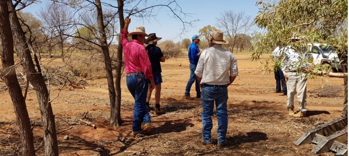
Figure 1 shows Southern Queensland Landscapes Project Officer Glenn Landsberg talking with local landholders about the expected impact of the weirs. At this this time, the LCAT land score for the area was 10/100.
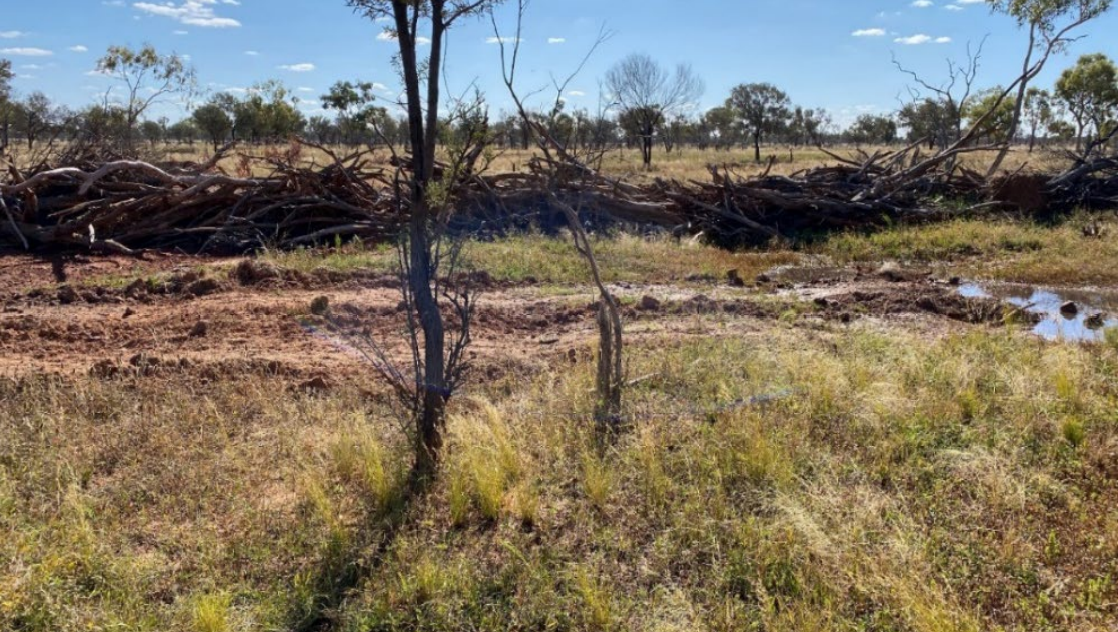
Following a few rain events, Figure 2 shows a weir during November 2020. The impact of the weir is still relatively localised at this point, but has improved the area’s LCAT land score to 19/100. The land manager confirmed that ground cover in the area at this time was notably higher than previously.
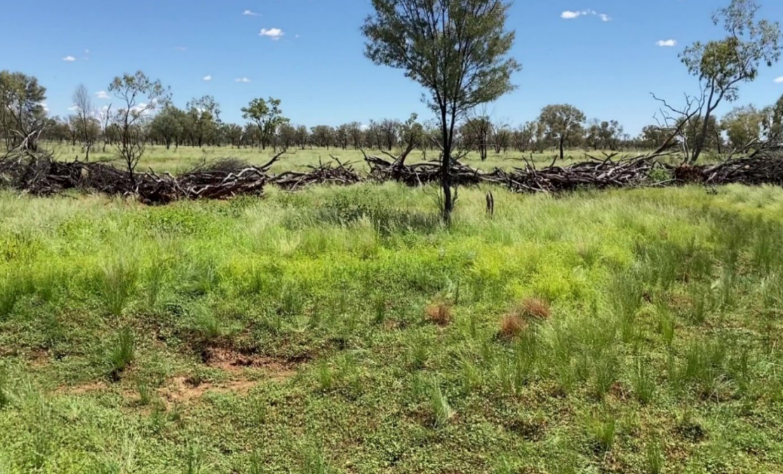
Figure 3 depicts the same section of weir in late February 2022. A drastic increase in ground cover can be seen when compared to when first constructed.
The benefits of the slowed overland flow are clear. At this time the LCAT score had increased to 94/100. The land manager also noted that the pasture tended to persist longer following rainfall events.
Following the installation of the weirs, the land manager estimated the water from heavier rainfall events persisted in the improved areas for over 48 hours. This slowing of the overland flow results in improved soil infiltration, reduced erosion, and improved pasture growth. As the landholder puts it “we’re going to be slower going into drought and getting out much quicker.”
Stocking rates on the trial sites is kept low to maximise rehabilitation success. Since the floodplain was historically some of the best pasture on the property, they will likely be able to return to sustaining higher stocking rates in the coming years.
Overall, sheep, cattle and native birds have been positively impacted by the improvements. Sheep and cattle have benefitted from ongoing management and appropriate stock rotation and grazing management. It is anticipated that, with time, the works will improve the stocking rates of the whole property while improving land condition.
An added benefit of the work has been the return of some native bird species that had noticeably declined during the dry periods and degradation of their natural habitat.
The overall cost of the work has been relatively low in comparison to the realised gain. The cost to the land manager to undertake the works were limited to:
- the running costs of the loader
- grader hire
- time required to undertake the laser levelling and surveying.
The land manager has commented that the only recurring cost included the costs associated with using the grader to repair damage caused by big rain and flood events. He also commented that the repair works also give him an opportunity to improve the banks or correct any flaws.
Once the water was slowed, it opened the opportunity to continue with similar leaky weirs further downstream. The land manager now has a large-scale fencing program complete, enabling total ongoing management of grazing pressure. As a result, the floodplains will be prevented from being stripped of vegetation once revegetated.
Conclusion
The land manager comments that while it is too early to quantify economic benefits, there has been a definite increase in pasture persistence. The results can be seen by satellite imagery and has the land manager on-ground eager to do more.
“I’ve got a lot better understanding (since attending the Avondale landscape restoration field day) as to why it probably wasn’t functioning as well as it used to, because suddenly an area where water use to flood (now has) a little erosion feature (that) can drain it out in no time flat. Often small works (such as a short contour bank in front of an erosion feature) can make a big difference” – Land manager.
Created by Lucas Mackie and Leanne Stevens, Southern Queensland Landscapes, May 2022
Click here to access the full case study Leaky weirs and low profile contour banks restore floodplain.
Read more
GrazingFutures Livestock Business Resilience →
Cubbaroo Station: Addressing erosion issues after a 1-in-100-year flood →
Sunset: Spreader banks for water retention →
https://futurebeef.com.au/wp-content/uploads/2022/04/Recovery-Restoration-and-Resilience-DCAP-2.pdf