Cubbaroo Station — Addressing erosion issues in the Southern Gulf
A GrazingFutures Case Study — compiled by Southern Gulf NRM
The Southern Gulf region
Years of drought followed by an unprecedented flood event resulted in areas of severe erosion within the Southern Gulf region.
The Southern Gulf region, located in north west Queensland, incorporates five catchments, draining into the Gulf of Carpentaria. The 19,479,540‐hectare area is comprised of many land types but can be broadly categorized into three major bioregions: Gulf plains, Mitchell grass downs, and Mount Isa inlier.
Gulf plains range from coastal salt flats and mangroves to large expanses of bluegrass plains and woodlands. Mitchell grass downs, with its largely undulating plains dominated by Mitchell Grass, are highly fertile. The soils are self‐mulching, deep, heavy grey or brown clays. Further towards the Northern Territory border is rough spinifex hills with mostly red skeletal soils, dominated by snappy gum.
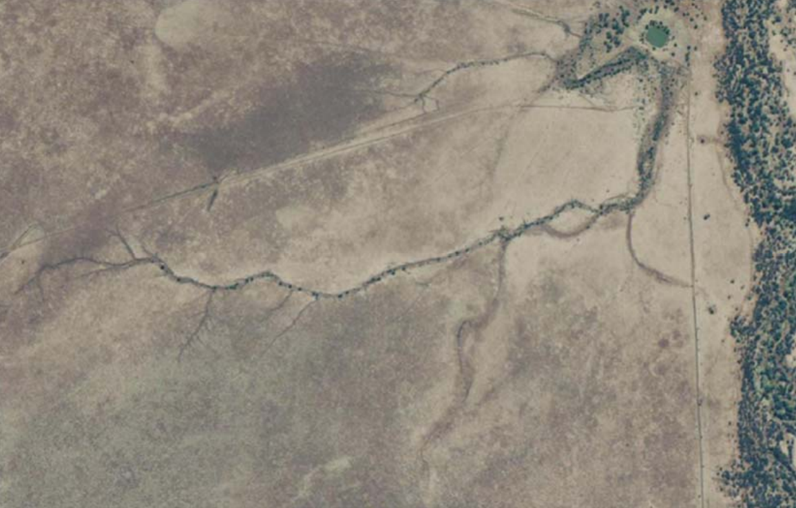
The types of erosion after the flood included extensive scalding, floodplain sheet erosion, as well as gully and streambank erosion. Erosion occurred across much of the region and will have a long‐term impact on land condition recovery. The flowing water also scoured out many new drainage lines.
Andrew “Drew” and Annie Hacon of Cubbaroo Station, Cloncurry, are conscious of the environmental and productivity impacts erosion is having on their business’ resilience.
Drew’s approach to this major erosion remediation project stemmed from an erosion control and remediation workshop he attended in 2019. The event was led by Darryl Hill, founder of Soil Save, and Bob Shepherd, Principal Extension Officer with Department of Agriculture and Fisheries.
Introducing Cubbaroo Station
“Our commitment to preserving our grazing land is something we have always felt passionate about. We have had a long‐held program of resting country and avoiding overgrazing which we believe has been beneficial financially and environmentally.” — Drew Hacon
Drew and Annie Hacon run up to 2000 head on Cubbaroo. The property consists of Mitchell grass on cracking clays, blue grass and silky brown top plains, river frontage, open red country and pebbly gidgyea ridges.
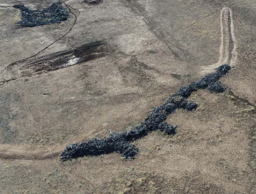
During the 2019 flood, parts of Cubbaroo suffered severe erosion. One area that Drew and Annie were extremely concerned about was a large channel formed from a well‐worn cattle pad. The top section of the ridge was in A to B land condition, with strong grey‐brown clays and a prolific body of Mitchell grass. The land type closer to the watering point evolved into more fragile, ashy black soil. This area experienced pasture and soil damage while submerged during the flood.
Cubbaroo erosion site
“In the last 10 years we have experienced more than one severe weather event, which has accelerated the erosion in some areas, and we felt it was imperative to prevent these areas deteriorating before it was too late to intervene. While we appreciate some erosion is historically acceptable and a natural progression of land type, most erosion can be managed and prevented by simple practices.” — Annie Hacon
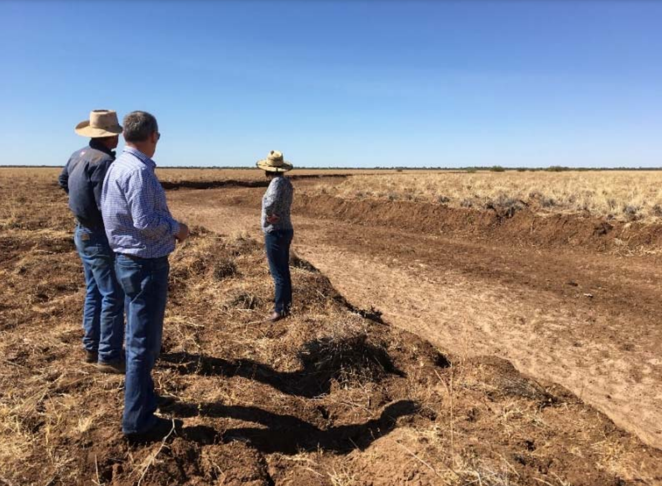
The mild erosion started as fingers of gullies branching down the undulation. By the end of the 2019 flood, a significant channel and broad snaking gullies had formed. The area directly affected by erosion spanned approximately 168 hectares.
Drew and Annie were dismayed that such extensive erosion could occur despite their conscious efforts of maintaining good land condition. Drew remarked:
“If we continued to let the eroded channel go without intervention, it wouldn’t be too long before it continued right up the ridge and took half the paddock with it.”
Nutrient rich topsoil, carrying a vibrant seedbank was being washed down the creek. Not only was this silting up the downstream dam, but also eating away at productive pastures. Now, instead of the thick Mitchell grass tussocks that were previously there, the area barely grew annual grasses.
Based on figures from Best‐bet practices for managing the Mitchell grasslands of Queensland, the affected eroded area that had declined to a land condition of D, was now rated at 25% of its long‐term carrying capacity. Land in D condition has 75% less pasture growth and ability to respond to rain.
Climate modelling has predicted weather events in north west Queensland, such as rain or heatwaves, to trend towards ‘more extreme’ in coming years. Without intervention, the eroded gully could potentially double in size over the next 10 years (13% of the 2590‐hectare paddock).
Remediation effort
A minor attempt at repairing the issue was made at the end of 2019 but was unsuccessful. The attempt entailed erecting piles of rocks at the head of the newly formed gully and again at intervals downstream. The idea was to use the rocks as a porous weir, slowing the water, as it flowed toward the creek. Despite the mediocre wet season that followed, the rocks washed downstream, and the eroded gully snaked higher and wider.
Projects like Profitable Producers Creating Healthy Landscapes Across Southern Gulf and GrazingFutures Livestock Business Resilience meant the Hacons’ were provided with one‐on‐one access to soil conservation professionals. Darryl Hill and Bob Shepherd shared their experience and knowledge, to which the Hacons’ combined with their own extensive research and experience, to construct a second remediation plan.
“Having access to expert advice before undertaking erosion remediation projects can be the difference between success and an environmental disaster.” — Bob Shepherd
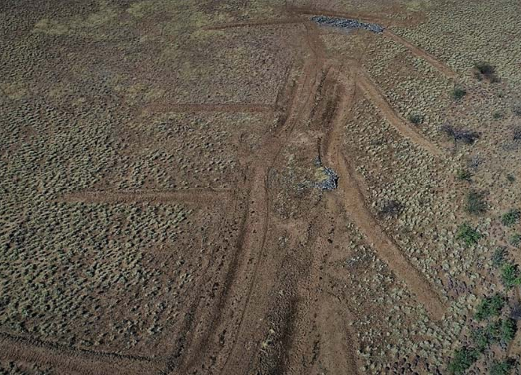
Step 1. Battering the land
A D9 Bulldozer was brought in to batter the top section of the erosion site out. The area affected by erosion totalled 168 hectares but the site that was directly worked on was approximately 55 hectares. ‘Battering’ means to smooth the land to be as flat as possible. Doing so reduces the opportunity for water to break over any sharp soil edges and cause further erosion. A 40‐foot spreader bar, towed behind a loader, put the finishing touches on the battering. Drew commented:
“The spreader bar was particularly valuable to the process as it removed rough edges which would limit water breakover, and the ground could be smoothed as close to the original ground level as possible.”
Step 2. Contour banks and drains
Contour banks, also known as check banks or bunds, are low earthen banks used for diverting and collecting moving water. The soil for the contour bank is taken from the flat bottom, wide drain that is created at the lower end of the contour bank, pooling and taking the energy out of fast‐moving water. Water then spreads out onto the landscape at a much slower pace than what it entered.
“The intention of the erosion remediation was to not alter the natural flow of the fast‐moving water, but to catch it, slow it down and focus it in a large, wide area where it can spread out and flow away slower and with less energy that what it entered.” — Georgia Glasson
When planning contour banks, it is best to use a dumpy level to accurately survey the ground. Flat, open downs country can be especially deceiving. Having grown up and spent much of his adult life on Cubbaroo, Drew had a fair idea of the natural flow direction of the water, so planned most of the contour banks by eye.
When asked if he would have done anything differently throughout the project, Drew said:
“Next time I will use a dumpy level to plan the contour banks to make sure they are aligned with the natural flow direction. After the check banks and flat bottoms drains were built, Darryl came back to Cubbaroo, and we surveyed the banks using a dumpy level. We were spot on with most of them, but a few needed some adjustments.”
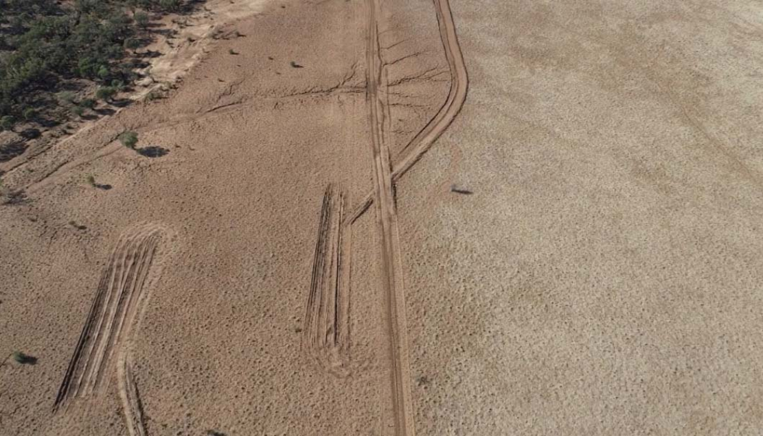
Step 3. Natural leaky barriers
‘Bush filters’, or ‘beaver walls’ as the Halcons’ labeled them, were next in the pipeline for the erosion site.
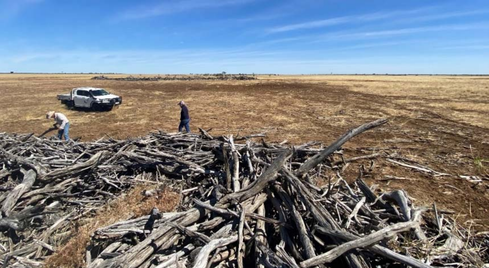
The bush filters consisted of piles of gidyea logs placed across the main gully. The logs act as a leaky weir, slowing water down for a prolonged period but not blocking it altogether. As the water flows through, sediment gets trapped on the top side of the logs and builds up, slowly filling in behind the pile.
Piles of stick raked gidyea logs were carted from paddocks to the erosion site via two hired tip trucks. The Cubbaroo team had engineered a set of forks that attached to the loader bucket to pick up log piles. At each site, a loader dug out a small pit for the log piles to sit in. The aim was to slow the water and reduce erosion by creating an area for fast moving water to pool, and then seep downstream slowly.
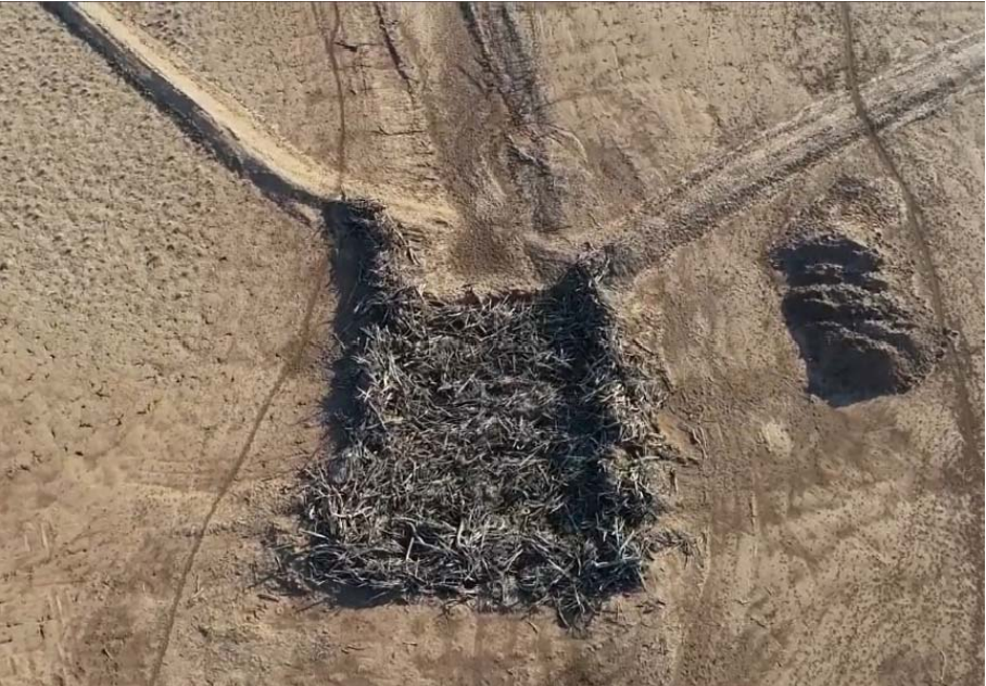
October 2020 – Another leaky barrier further upstream at the erosion site at Cubbaroo Station
Step 4. Seeding for ground cover
It is evident from the consistent good land condition on Cubbaroo that the Hacon’s appreciate the value of ground cover. At the erosion site, there was very little ground cover as much had been washed downstream. That area was now part of a vicious cycle. Where there is minimal ground cover, there is no protection for grass, plants, litter, or mulch, to slow the water down for infiltration. As there are few plants, there are few root structures to keep the soil stable.
Three hundred kilograms of grass seed was flown onto the erosion site after the earthworks were completed. The seed mix included 40% Mitchell grass, 40% Signal grass and 20% Jap Millet seed.
Project expenditure
NB: Dry hire equivalents have been included to replicate project cost for someone that owns no machinery. The grader, scraper and loader were owned by the Hacons. The table below lists all the Halcon’s costs involved in this erosion project, excluding some machinery hire costs.
| Descritpion | Quantity | Unit price | Total price |
|---|---|---|---|
| Machine (hours) | |||
| Dozer hire | 25 | $150 | $4125 |
| Tip truck hire x 2 | 69 | $120 | $9130 |
| Grader (dry hire equivalent estimates used) | 42.5 | $180 | $8415 |
| Scraper (dry hire equivalent estimates used) | 107.5 | $210 | $24,832 |
| Loader (dry hire equivalent estimates used) | 62.5 | $220 | $15,125 |
| Helicopter | 1.3 | $400 | $572 |
| Fuel (litres) | |||
| Loader diesel @ 15L/hour | 937.5 | $0.96 | $900 |
| Dozer @ 65L/hour | 1625 | $0.96 | $1560 |
| Grader @ 15L/hour | 637.5 | $0.96 | $612 |
| Scraper @ 20L/hour | 2150 | $0.96 | $2064 |
| Tip truck diesel x 2 | 450 | $0.96 | $432 |
| Labour (hours) | |||
| 3 x full time employees | 281.50 | $20 | $5630 |
| Contract dozer operator | $3960 | ||
| Other | |||
| Seed | 300 | $65 | $4504.50 |
| TOTAL COST | $81,862 | ||
| Cost per hectare | $487.27 | ||
All the on‐ground erosion remediation work completed in the project was undertaken at the Halon’s own expense. In Annie’s judgment:
“It was a significant cost but in terms of future productivity of that particular parcel of land, the work we have done has been invaluable.”
12 months on at Cubbaroo
The 2020‐21 wet season was favourable of the erosion site with early falls stimulating some pasture growth and no severe rainfall events.
Contour banks and flat bottom drains prevented further gully erosion. Rainfall (40 mm) in a short, sharp storm in early September 2021 indicated that the leaky barriers were effective. Ground cover has increased where the eroded gully has been battered and seeded. The decelerated pace of the water now allows for water infiltration into the soil. Intertwined throughout the log piles are tussocks that have sprouted. Annie added:
“The seed mix was expensive, but we are extremely happy with the response we have seen after the last wet season.”
Pasture recovery will take many years and requires ongoing maintenance of the manmade remediation structures, and careful grazing management. Drew and Annie plan to fence off the area, so they have full control over livestock grazing pressure. Doing so will lessen the risk of inhibited landscape recovery while still lightly utilizing the grass for beef production.
Good grazing land management is imperative for ongoing remediation success. The Halcons’ will use remotely sensed ground cover monitoring to measure the success of their efforts. The Hacons’ stated:
“While it is still early, we believe the time and expense of the project has been essential. The site seems to have responded in the way we had hoped, and we will continue to monitor it in the hope that in the long term, we can return the country into stable soils with a strong mix of native vegetation suitable for grazing.
“We have been progressively fencing off dams and installing water points to avoid the dust bowl hotspots that can cause significant erosion. Our long‐term goal is to eventually every dam will be fenced off, preserving water quality, preventing erosion and removing the risk of cattle bogging when dams become low. We are confident this will preserve the viability of our country and its grazing capabilities for future generations.”
Recognising initiative and achievement
This erosion project is one of the many examples of the passion that Drew and Annie display. They are committed to adopting sustainable land management practices to achieve healthy land condition and native pastures. Drew and Annie were awarded Southern Gulf NRM’s Sarus Crane award to recognize their leadership, innovation and commitment to the region’s sustainable future.
This has been an abridged version of the wonderful case study written by Georgia Glasson, Southern Gulf NRM, December, 2021.