Pasture photo standards
Page published: September 20, 2011 | Page reviewed: January 6, 2025
Pasture photo standards are an essential tool in good grazing land management. They will help you develop pasture budgets and dry season business management plans. There are photo standards and corresponding pasture yields for many of Queensland’s common pasture communities (based on region or pasture species).
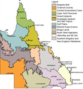
Select a region to view the pasture photo standards for that region:
- Brigalow Belt
- Channel Country
- Central Queensland Coast
- Cape York Peninsula
- Desert Uplands
- Einasleigh Uplands and Wet Tropics (including the Burdekin)
- Gulf Plains
- Mackay Whitsunday
- Mitchell Grass Downs
- Mulga Lands
- North West Highlands
- Wide Bay and South East Queensland
- Southern Brigalow and New England Tablelands
Or select a specific pasture photo standard:
- Alluvial (PDF, 417KB)
- Basalt (PDF, 442KB)
- Black speargrass (PDF, 580KB)
- Bluegrass, wiregrass (PDF, 489KB)
- Buffel grass (PDF, 925KB)
- Buffel regrowth (PDF, 493KB)
- Downs country (PDF, 488KB)
- Eucalypt woodlands (PDF, 490KB)
- Eucalyptus box and stylo (PDF, 488KB)
- Eucalyptus box (PDF, 446KB)
- Indian couch (PDF, 709KB)
- Kazungula (PDF, 1MB)
- Lancewood, bendee, rosewood and spotted gum (PDF, 317KB)
- Maranoa Mitchell grass (PDF, 1MB)
- Mitchell grass (PDF, 723KB)
- Mulga (PDF, 847KB)
- Narrow-leaved ironbark (PDF, 635KB)
- Northern Gulf black soils (PDF, 1MB)
- Northern Gulf frontage (PDF, 1MB)
- Northern Gulf granite (PDF, 1MB)
- Northern Gulf range soils (PDF, 1MB)
- Northern Gulf red basalt (PDF, 1MB)
- Northern Gulf red duplex (PDF, 1MB)
- Northern Gulf red earth (PDF, 1MB)
- Northern Gulf yellow earth (PDF, 1MB)
- Purple pigeon grass (PDF, 552KB)
- Pangola grass (PDF, 2MB)
- Rhodes grass (PDF, 2MB)
- Sandstone aristida (PDF, 370KB)
- Sandstone forest (PDF, 489KB)
- Signal grass (PDF, 2MB)
- South East Queensland black speargrass (PDF, 580KB)
- South East Queensland bluegrass, wiregrass (PDF, 438KB)
- South East Queensland forest bluegrass (PDF, 476KB)
- South East Queensland poplar box (PDF, 2MB)
- Silver-leaved ironbark (PDF, 449KB)
- Spinifex desert uplands (PDF, 455KB)
- Traprock (PDF, 372KB)
- Tully grass (PDF, 1MB)
- Upper Herbert black basalt (PDF, 541KB)
- Upper Herbert frontage (PDF, 546KB)
- Upper Herbert red basalt (PDF, 583KB)
- Upper Herbert red earth (PDF, 503KB)
- Upper Herbert yellow earth (PDF, 534KB)
‘Land condition photo standards for the Burdekin dry tropics rangelands’ are also available from NQ Dry Tropics, email or phone 07 4724 3544.
Download the Stocktake GLM app to access photo standards, land type factsheets and much more from your mobile device.
For more information
- Land types of Queensland
- Land condition
- Managing land condition
- Guide to Pasture Photo Monitoring
- Rolling ball model – a slippery slope to poor productivity
| Topics | Tools and calculators Land types and photo standards Photo standards |
|---|
| Share |
|---|