Land condition
Land condition determines the capacity of grazing land to produce useful forage.
It is a measure of how well the grazing land ecosystem is working:
- how well sunlight is being captured and converted into feed,
- how well nutrients are being cycled, and
- how well rainfall is being used to grow grass.
Land condition is therefore directly related to carrying capacity, livestock production and profitability of a grazing enterprise.
In this article, we discuss:
What land condition is
Indicators of land condition
Classifying land condition
Examples of change through management
What is land condition?
Land condition is a relative and arbitrary measure of the health of grazing lands. It is determined by assessing multiple land condition indicators;
- soil condition
- pasture condition
- woodland thickening
- weeds
and giving the area an overall score that is related to the lands ability to produce useful forage:
- A condition – good condition and 100% of original carrying capacity
- B condition – fair condition and 75% of original carrying capacity
- C condition – poor condition and 45% of original carrying capacity
- D condition – very poor condition and 20% of original carrying capacity
Indicators of land condition
Soil condition
Soil condition determines the capacity of the soil to absorb and store rainfall, to store and cycle nutrients, to provide habitat for seed germination and plant growth, and to resist erosion.
High presence of organic matter and good soil structure are key indicators of soil condition. Compare the soil surface condition around a grass tussock to that in a bare or scalded area.
Erosion is another key indicator of soil condition. Signs vary with the form of erosion. Inter-rill or sheet erosion is the loss of thin layers or sheets of soil in each successive storm and can eventually lead to the loss of all top-soil. As water concentrates into discrete flow paths, it forms rill erosion, seen as tiny gullies. As these rills widen and deepen, they form gully erosion.
Scalding is the result of massive loss of top-soil in texture-contrast or duplex soils. The sub-soil, when exposed, is typically hard when dry and has very low infiltration rates.
Pasture condition
Pasture condition determines the capacity of the pasture to capture sunlight and convert its energy into palatable green leaf, to use rainfall efficiently, to conserve soil condition and to cycle nutrients.
The density and coverage of 3P grasses (perennial, productive, palatable) is a key indicator of pasture condition. 3P grasses are vital in providing quality and quantity of feed for grazing and grass coverage is important for capturing sunlight efficiently and keeping moisture and nutrients in the paddock.
Maintaining ground cover above 50% is essential for minimising runoff and loss of nutrients and soil. Low ground cover results in less sunlight being used by plants and poor water use. Pasture also maintains soil organic matter, thereby stimulating soil organisms and promoting soil structure.
Woodland thickening
Woody plants can stimulate the ecosystem by acting as nutrient pumps and reducing water loss via evaporation, however, they can also use resources that could otherwise be directed towards forage production.
As tree size and density increases, annual pasture growth (kg/ha) also declines, and the paddock subsequently has a reduced capacity to carry stock.
Tree basal area (TBA) is a measure used for calculating tree density. It is an estimate of the tree or shrub trunk size per hectare of area.
Weeds
Weeds compete with the desirable pasture plants for light, nutrients and water. Some weeds also hinder stock movement and others may be toxic to cattle, such as rubber vine and lantana. Weed infestations are often associated with declining land condition, as weeds are able to exploit disturbed and bare areas, taking advantage of reduced competition from pasture.
Classifying land condition
Land condition can be classified into four broad categories:
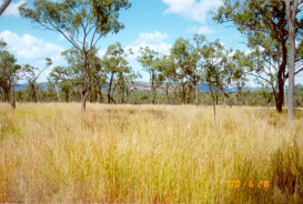
Good or A condition
A condition, (Figure 1) has all the following features:
- Good coverage of 3P grasses (perennial, palatable and productive) for that land type with less than 30% bare ground
- No significant weed infestations
- Good soil surface condition and no erosion
- No sign, or early signs, of woodland thickening
- 100% long-term carrying capacity.
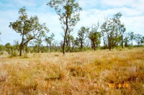
Fair or B condition
B condition (Figure 2) has at least one or more of the following features, but otherwise is similar to A condition:
- Some decline of 3P grasses; increase in other species (less favoured grasses, weeds) and/or bare ground (more than 30% but less than 50% in most years)
- Some decline in soil condition; some signs of previous erosion and current signs of erosion risk
- Some thickening in density of woody plants
- 75% long-term carrying capacity.
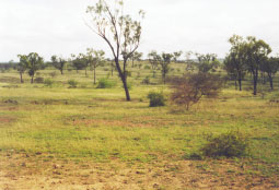
Poor or C condition
C condition (Figure 3) has one or more of the following features, but otherwise is similar to B condition:
- General decline of 3P grasses; large amounts of annuals, less favoured species and/or bare ground (greater than 50% in most years)
- Obvious signs of past erosion and/or current susceptibility to erosion is high
- General thickening in density of woody plants
- 45% long-term carrying capacity.
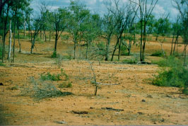
Very poor or D condition
D condition (Figure 4) has one or more of the following features:
- General lack of any perennial grasses or forbs
- Severe erosion or scalding, resulting in hostile environment for plant growth
- Thickets of woody plant cover most of the area
- Less than 25% of long-term carrying capacity. Often no long-term ability to carry stock.
On any land type, each of the condition categories may be represented by more than one form or ‘state’. For example, A condition land may be represented by different mixes of 3P grasses (including exotics). Similarly, D condition land may be represented by lack of 3P grasses, or by extensive loss of soil condition. The four broad condition categories provide a means of ranking these ‘states’ with respect to their ability to grow useful forage.
Land condition can change due to natural events (e.g. drought) or due to grazing land management practices (e.g. stocking rates, fire, weeds) of the landholder. In the early stages of land condition degradation, the condition of the land is responsive to a change in management. Degradation is judged to be severe if it is irreversible over a reasonable time scale and/or is expensive to rehabilitate. The rolling ball model demonstrates these principles.
To prevent degradation and monitor the effect of natural events and management practices, it is recommended to implement regular monitoring across your property. This can be done through a simple process called photo monitoring.
Examples of land condition improvement through management change
Check these out:
Leaky weirs and low profile contour banks restore floodplain
Addressing land condition issues at Ametdale: part of the Northern Grazing Demonstration project
Riparian fencing and off stream water – a win : win for the McDowells
More information
- Rolling ball model – a slippery slope to poor productivity
- Land types in grazing land management
- Pasture photostandards